
Adrian Kavanagh, 24th September 2018
A new boundary report was published today by the Constituency Commission, outlining the new European Parliament election constituency boundaries that will be in place at the next European elections in May 2019. BREXIT and the subsequent surrender of the United Kingdom’s European Parliament seats has led to the Republic of Ireland gaining an extra two seats in that Parliament. This report redrew the Irish election constituencies, taking those two added seats into account.
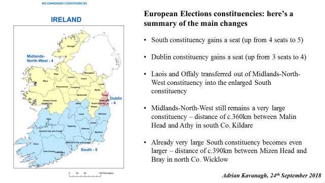
The main changes made by the Commission may be viewed in this image below:
In terms of the European Election constituencies, there is a notable difference between the amount of territory covered by the very smallest constituency, Dublin, and the other two, more rural constituencies, in terms of population densities, but especially in terms of geographical area/territory.
At the last European elections in 2014, the Midlands, North and West constituency covered an area of 37,286.6 km2 – effectively 53.1% of the state territory. The South constituency, with an area of 31,975.0 km2 , covered 45.6% of the state territory, while the area covered by the Dublin constituency (920.7 km2 ) just accounted for 1.3% of the state territory. To put this into context, the constituency areas of the Midlands-North-West and South constituencies were larger than the territories covered by five European Union states, namely Belgium, Slovenia, Cyprus, Luxembourg and Malta, while the Dublin constituency could fit forty times within the Midlands, North and West constituency territory.
With the new report, the South constituency now emerges as the largest of the three European election constituencies in territory/area terms, as well as population (thus accounting for this constituency’s allocation of five European Parliament seats). The South constituency now covers an area of 35,684.3 km2 – effectively 50.8% of the state territory. The Midlands-North-West constituency, with an area of 33,577.3 km2 , now accounts for 47.8% of the state territory, while the area covered by the Dublin constituency (920.7 km2 ) still only accounts for 1.3% of the state territory.
And yes…the constituency areas of the South and Midlands-North-West constituencies still remain larger than the territories covered by five European Union states, namely Belgium, Slovenia, Cyprus, Luxembourg and Malta.
There are a number of ways in which the destinations of the seats in these (revised) European Parliament constituencies could be teased out in a scientific manner – with respect to analyses based on factors, such as who/what party came closest to a seat last time out (2014), current poll trends, vote management strategies, among others. However, as befits their status as effectively “mini-presidential elections”, personality politics often trumps “normal” politics/current poll trends in a European election contest and this often means that a scientific approach is of limited, or little, benefit in predicting likely winners here. Pick the right candidate and your party/grouping may pick up a seat you didn’t expect to win. Pick the wrong candidate and your party/grouping may lose out on a seat that current poll trends suggested you would gain/retain.
